Per a recent newsletter (see page 2, midway down), the airport connector to the Montour Trail is expected to be done this year.
2011-11-04 19:16:09
While dropping someone off at PIT last night, I noticed while driving away that there were some "warning - bike crossing" signs put up as you head back to 376 - sort of near where the gas station is. But I couldn't see anything actually looking like a rideable road on either side of the signs. Is this part of some future connection to the Montour Trail? Anyone know any more?
Per a recent newsletter (see page 2, midway down), the airport connector to the Montour Trail is expected to be done this year.
Oh, nice!
I know a teenie bit about it - I work at the airport. I'm told that most of the trail connector is done, some cement curbs were still to-do last weekish.
I may go do a recce ride and I'll post a gps track in the next few days.
< conspiracy rant> It has seemed like a few bike trail announcements have been in slow-mo - the Airport Connector, the SouthSideWorx plaza, the SC connection. At one time, 11/11/11 was supposed to be a Big Day 4Bikes. The cynic in me wonders if no politician wants to be associated with a bike trail in these trying economic times.< /conspiracy rant>
Because bike infrastructure was completed in such a prompt and delay-free fashion prior to the recession?
I think this stuff just takes a really long time, always. The Montour is now on year 22 or so of their 2 year trail construction project, if I recall correctly, and is still roughly 2 years from finishing the trail....
But despite that, we got lots of new trail in 2011, and 2012 will be the same.
Also, the Airport connector, like the rest of the Montour, is mostly done by volunteers. Politicians help with the funding, of course, but I don't think they have much to do with how long the subsequent construction takes.
I must be really late finding out about this trail. So.... It goes from downtown to the airport? Is it 100% trail or some trail and some road? And where does it start?
Actually, there were two or three critical steps in the airport connector project. The first was to get the airport to believe that there was a need, which to their credit they were pretty quick to pick up on. Once on board, they were more than helpful, offering suggestions on routing, etc that were really helpful. The biggest challenge, for them, was the need to cross the 12 lanes (or whatever) of airport circulator road traffic safely. They looked at a number of locations for such a crossing, and then worked with the trail group and others to find the money to construct the crossing and the warning signs/lights. In talking to the airport folks, I think they are actually sort of excited about this new connection. I suspect the first "thru rider" who flies into the airport may get a warmer welcome than they might have anticipated.
P.S. Before the "new" terminal was built, there were a number small roads in this area, some heading to off airport locations, some serving on airport facilities that the public would never need to get to, like the weather station, fire training facility, etc. Because of the location of the new terminal, many of those roads are no longer in use by the airport. Those are routes that they've offered for use as part of the trail. So, construction is really limited, for the most part. The crossing into the airport, where traffic is a) distracted and b) not expecting to see bicycles (or any cross traffic) was the biggest challenge.
where will it connect to the montour trail at near what mile marker id like to ride it sometime when its finished
Dude, there should be an Airport Flyby Ride... bike to the Airport for snacks at Au Bon Pain (or a beer next door), then back down the trail to... whatever is down there?
Is there secure bike parking? Or are they assuming everybody will either take their bike with them or not be flying out?
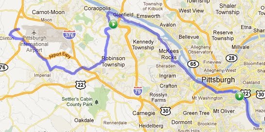
The new trail doesn't go downtown (but maybe someday). It connects from the Airport to the Montour Trail at Enlow Road, mile post 7.8 or so. That's the road by Enlow Station, the ice cream place right off the trail, a little west of the Enlow tunnel.
It starts off as a signed on-road route on Enlow Road, and winds up entering the airport's long term parking from the west, I think. They're supposed to describe the route in more detail in the next newsletter at the end of November.
I guess a ride from town could go via the North Side, McKees Rocks bridge, Neville Island, then pick up the Montour outside Coraopolis. But that's 23 miles from downtown to Enlow Road, plus another few miles to the airport. Pretty long.
Idea #1: Pairs of bikes on a 28X to Ikea, drop down to the M.T. where Ikea/FedEx/RobinsonTownCtr is about MM4.5, hang a left, and off you go.
Idea #2: My path to FedEx was McKees Rocks Bridge, R PA51, L Tunnel Way (Stowe Tunnel), R Broadway, R Pine Hollow, L Fairhaven (brief non-trivial climb), R Clever, continue onto Montour Run, R-L at Old Beaver Grade, L onto trail.
The 28X runs every 30 minutes, so maybe combine that with the 21 (every 20-60 minutes M-F, 60 min Sat, 120 min Sun), and the 29 (every 30-60 minutes, M-F only), depending on the day. Maybe add the #14 to Sewickley, then (optionally) the #21 inbound into Coraopolis.
Getting from the trail back up to the 28X requires a long climb up roads with no sidewalks (but fairly wide). I find riding 6 miles into Coraopolis and taking the 21 is far easier.
OT: I loathe the 28X. Kind of embarrassing as a route that probably more people from out of town take than any other.
I rode the Airport Connector today.
I was unable to figure out how to get to the terminal complex. During the week, I may park at the terminal and try to suss out the route backwards.

Sounds like maybe a start and end somewhere near the icecream at Enlow might be a good idea... we don't have to start every ride at Dippy, as awesome a reptile as it (he?) is. Or maybe somewhere else on the Montour trail. I just perked up at the thought of icecream. "Icecream" is a much better attention grabber than "airport".
I've been obsessing over the idea of late-night rides to the IHOP, just a couple miles down the trail from Enlow. The idea of riding for a couple of hours, filling up on pancakes and coffee, then pedaling gently back to town along the trail &tc really appeals.
A Spring event:
Many people love to eat warm pancakes covered with butter and syrup in the morning. But did you know that there is actually a holiday where people celebrate and eat pancakes with their families and friends? It is a tradition that started many years ago in England.
Pancake Day is celebrated on Shrove Tuesday which is the day before Lent. Lent is a Christian holiday that was established in the 4th century as 40 days and is generally a period of fasting or other forms of self-denial. People generally eat a lot and have fun the day before Lent begins. Shrove Tuesday is often referred to as Pancake Day because fats, which were generally prohibited during Lent, had to be used up. People would take all the eggs and dairy products that they had left in their kitchens and use them to make delicious pancakes.
ejwme, I am sorry to disappoint, but there won't be any ice cream at Enlow Station until spring time. they're closed for the winter.
All you people riding past my house and not stopping by to say hello. Shame. At least I'm not the only one commuting this distance though. The back roads are key to getting around out here. Maybe I'll ride that on Friday and check it out. FYI, if you're out this way and want food or ice cream the road across the street from Enlow Station (California Hollow) will take you (safely) up the hill to the high school just continue straight to a bunch of shops and a King's and McD's and Subway... You probably know that, but maybe not.
I was out there again today and saw this signage on the Montour Trail at Enlow Road.
I hadn't noticed it the other day.
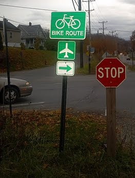
Exciting stuff.
Also, I should mention that on a weekday, those airport service roads are active with vehicles. Today I saw three or four airport trucks (yellow with big red numerals on the sides) as I rode the Connector.
I tried to wave happily at every one, as I did to the drivers along Enlow Rd - no reason not to try to make a good first impression, especially as we're new to their 'hood.
^that's a great sign!
I like that the bike is above the airplane, and I wonder if any other city in the world has these two icons together on the same directional sign?
Design-wise, it is kind of funny that the bike is headed left, the airplane, up, and the arrow is pointing to the right.
")
When leaving the airport late Monday, there was a cruiser bike parked outside one of the booths, presumably belonging to the attendant.
@Helen - wow, that is awesome!
The Denver airport access road has a sign that suggests cyclists may use the shoulder to get there. But I suspect that being 25 miles from downtown, few people really use it to get out there.
For that matter, at 20+ miles to the Pittsburgh Airport from town, I can't envision myself taking this new trail connection route except on a very long weekend ride.