Isnt that private property owned by the railroad?
2013-09-11 08:21:47
So my question is, who (what organization?) is spearheading this section of the trail?I don't believe there is any current effort other than wishful thinking at this point. There was talk of development happening on that land but I haven't heard anything about it lately.
paulheckbert wrote:Legally, the land along the RR tracks (I’m not sure exactly how wide a strip) belongs to CSX railroad, as that’s their RR track. Few trains run along those tracks. Some of the few that I know of are a morning Amtrak from Pittsburgh to DC and a late evening return Amtrak.I've asked around at work and I have been told that those RR belongs to CSX but CSX does not want them. It would gladly sell them long time ago but there is a government mandate that CSX should keep RR alive for Amtrak usage (and the cannot sell them to Amtrak -- the last one would not be capable to support them). So don't expect CSX doing something above absolute minimum to support them and infrastructure around.
 Connect the GAP Trail from the west end of the overpass bridge, using something like the existing unauthorized footpath, to the sidewalk on the southeast-side of the Rankin bridge. (iow, connect the red dots using a new Braddock Trail Connector.
With this connection, people from downtown, SouthSide, Homestead and McKeesport would be able to ride a trail and the bridge sidewalk into Braddock Avenue. This would also provide easy access for people who work along Second Ave (ie Union Switch & Signal, etc) to take the Hot Metal Bridge, Baldwin Trail, and the Braddock Trail Connector.
Then more people could ride and eat at the Braddock Community Cafe, which is like my fave bike - breakfast destination evah.
Elevator pitch line: There is no other single bike infrastructure investment that would connect Braddock to so many communities, because (1) connecting to the GAP connects to a trail network and (2) there's no dependency on other projects like ALOMONO completion.
Just sayin.
Connect the GAP Trail from the west end of the overpass bridge, using something like the existing unauthorized footpath, to the sidewalk on the southeast-side of the Rankin bridge. (iow, connect the red dots using a new Braddock Trail Connector.
With this connection, people from downtown, SouthSide, Homestead and McKeesport would be able to ride a trail and the bridge sidewalk into Braddock Avenue. This would also provide easy access for people who work along Second Ave (ie Union Switch & Signal, etc) to take the Hot Metal Bridge, Baldwin Trail, and the Braddock Trail Connector.
Then more people could ride and eat at the Braddock Community Cafe, which is like my fave bike - breakfast destination evah.
Elevator pitch line: There is no other single bike infrastructure investment that would connect Braddock to so many communities, because (1) connecting to the GAP connects to a trail network and (2) there's no dependency on other projects like ALOMONO completion.
Just sayin.
Pierce wrote:I’m hoping they’ll convert the Carrie Furnace Hot Metal Bridge for the same purpose,Yes, I understand. Just guessing but that's got to be a few years from now.
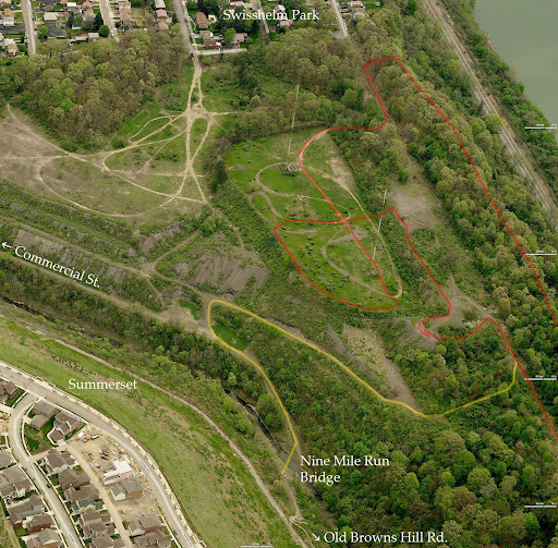
andyc wrote:What is the status of the plateau between the 9 mile run trail and the Mon (directly east of the duck hollow neighborhood)? An alternative route might be a legal connection through that area into Swissvale instead of having to go up Commercial St.This is part of Pittsburgh, as is the Swisshelm Park neighborhood (see map https://maps.google.com/maps?q=Swisshelm+Park,+Pittsburgh,+PA&hl=en&ll=40.418005,-79.902792&spn=0.0198,0.037036&sll=40.955011,-77.607422&sspn=5.293112,3.900146&oq=swisshelm&t=m&hnear=Swisshelm+Park,+Pittsburgh,+Allegheny,+Pennsylvania&z=15) and I understand that the long range plan for the Summerset development is to build another "slag heap village" if you will, on the Swisshelm Park side of Nine Mile Run, with a new bridge and road between them, someday. I found a map of one of their proposals here: http://www.city-data.com/forum/pittsburgh/1375275-summerset-beginning-phase.html For now, here is an annotated aerial photo that shows some of the trails (mostly hiking / mountain bike) on and near those slag heaps. If you explore that area, you'll run into: raspberry bushes, deer, and dirt bikers.
 Zoomable, full resolution version here: https://picasaweb.google.com/111415749895648787719/SteelValleyTrailNorthBank#5922566116710338258
 Pierce wrote:If Friends of the Riverfront is waiting on ALMONO, it sounds like it is going to take FOREVER.Regarding the goals of trails on the right bank of the Mon from Braddock all the way past Carrie Furnace, Duck Hollow continuing past the Glenwood Bridge, through Hazelwood, connecting to the Jail Trail, and better bike connections across the Glenwood Bridge and Rankin Hot Metal Bridge, my synopsis of the players and my sense of their attitudes: Friends of the Riverfront: favors it, has spent some money years ago getting a map made, but has not put much effort behind it in recent years. Their interest mostly ends at the Pittsburgh city line (just downstream of Carrie Furnace). Their energies have been elsewhere (Sandcastle, Pittsburgh-to-Erie connection). Tom Baxter is an optimist, so if he says "2 years", I'd multiply by 5. Steel Valley Trail Council: has been focused on Sandcastle and the GAP trail (left bank). Only a couple of SVTC people (me and Lois Liberman) have put much time into these right bank issues. SVTC's domain is trails along the Mon (both banks) between Glenwood Bridge and Clairton. City of Pittsburgh: doing nothing. Allegheny County: doing nothing, although there are some good pro-trail people in there, e.g. Dave Wright. At the Urban Redevelopment Authority, it seems that their priority is attracting developers to the Carrie Furnace site and my impression is that they want developer first, trail later. Getting bridges over RR tracks and over the Mon built to allow new industry into the Carrie Furnace site is a higher priority to them than building trails. They do not hold public meetings, that I know of. Rivers of Steel: They own Carrie Furnace. Their goal is historic preservation. Their first priority is protecting Carrie Furnace from scavengers and they currently fear that a bike trail could bring in scavengers. They don't want a bike trail past Carrie Furnace to open until Carrie Furnace is secured (whatever that means). They do tours of Carrie Furnace occasionally. Go on one. ALMONO: they want the Hazelwood brownfields to be a mix of industry and housing, with bike trails. They're coordinating with FOR on the Hazelwood Trail; they're currently doing construction at the north end of this property(?) so that's why part of the Hazelwood trail got closed last month. They do not want to create another mall of big box stores and huge parking lots. They see the housing part of the ALMONO site as young people who might be students or staff at Pitt and CMU, for example. They're trying very hard to learn the lessons of the Waterfront and mesh their new developments into the existing Hazelwood community, to strengthen Hazelwood rather than suck vitality out of it. They're good people; they're on our side. They hold public meetings. Go to them. CSX railroad: they want to keep doing what they're doing and bike trails are just an annoyance and a liability. They own most of the land in the south Hazelwood / Glenwood area that would be critical for a good connection between an extended Hazelwood trail, the Glenwood Bridge, and the Duck Hollow Trail. What Mikhail said about CSX not wanting the tracks through Duck Hollow is interesting. I guess that would explain why they didn't repair the gate that got broken on their service road. The boroughs of Swissvale, Rankin, and Braddock: I imagine there are people in those boroughs that would be quite supportive of the kind of trail network I favor, but I'm not in contact with them, currently. I'd love to hear from them. Contact me if you are one of them, please. So I think the current bottlenecks are: in south Hazelwood: CSX. in the Carrie Furnace area: the county, and Rivers of Steel.
Vannevar wrote:...on the other side of the river ... connect the GAP Trail from the west end of the overpass bridge [Whitaker bridge], using something like the existing unauthorized footpath, to the sidewalk on the southeast-side of the Rankin bridge.Yes, we should do that! That's a great proposal to make with the Steel Valley Trail Council. They'd need to buy the strip of land, or an easement to it, and build the trail. It looks quite do-able physically (I cleared the knotweed along that path a few years ago, but naturally it grew back. I have that connection marked on this map: http://tinyurl.com/dnmsyn). Who knows if the property owners would be agreeable, however.
Vannevar wrote:Do you think Roy might know who owns that property?I don't know Roy, but I do know AC's Real Estate search site. Working upstream from the bridge the property owners between the railroad and 837 appear to be - 0237-A-00075, Whitaker Schools, about 11K sq ft of trees (?!?) - 0237-A-00080, AC redevelopment auth, 40K sq ft - 0237-A-00100, Cornerstone Power LLC*, 3.86 ac - 0237-A-00175, owned by United States Steel, is only 16,814 sq ft but includes a long narrow corridor extending from River Ave (837) almost directly to the point where the trail crosses the railroad. Nearby are also - 0237-E-00120, USX, another 8K sq ft abutting Regional Trail Corp property - 0237-E-00110, USX, 6K sq ft. Here's where I suspect the coordinates don't quite line up with their aerial photo, or else USX owns a small chunk of someone's used car lot, scrapyard, or whatever that is. (the neighboring lot belongs to a private individual, but that individual appears to be dead...) * near as i can tell, a developer of solar-power plants, though what they'd do with less than four acres of wooded hillside I've no idea.